The Burned Watershed Geohazards (BWG) program helps California communities prepare before and after wildfire by providing maps, data, and rapid burned watershed assessments focused on the following mission areas:
Pre-Fire Hazard Assessment
The BWG program develops maps and data that proactively identify areas with the highest potential for post-fire hazards ranging from floods to debris flows. This is achieved through analysis of terrain, geology, geomorphology, and burn severity that inform computer modeling of flood and debris flow hazards.
This information can be used by local agencies for evacuation planning, long-term mitigation measures, and public communication. It can also be used to inform land management practices.
Watershed Emergency Assessment
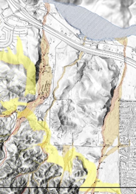
As the Watershed Emergency Response Teams (WERTs) technical lead, the BWG program evaluates post-fire conditions for potential hazards during rainfall events so that emergency mitigations can be implemented and appropriate evacuation plans can be developed. CAL FIRE, as a partner to the BWG program in the WERT process, plays a liaison role, communicating hazard information to local incident commanders and stakeholders.
The WERT assessment provides a means of prioritizing areas at risk of post-wildfire hydrologic hazards within and downstream of the burn area and development of emergency mitigation measures. These efforts are conducted after fires in areas where significant life safety hazards (people, property, public infrastructure) exist. The typical timeframe for assessment is two to three weeks from mobilization to completion.
Rainfall Threshold Evaluation and Development
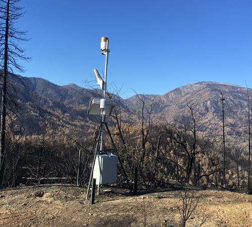 A portable weather station collects data on local rainfall and other meteorological variables that contribute to post-fire flooding and debris flows. Photo credit: Don Lindsay, CGS.
The BWG program, in collaboration with the U.S. Geological Survey, National Weather Service, CAL FIRE and the Governor’s Office of Emergency Services, determines rainfall thresholds that may trigger flood and debris flows on recent burn areas.
These rainfall thresholds are based on post-fire changes in hydrology, rainfall associated with historic post-fire runoff events, climatology of the area, and location of people, property, and infrastructure.
Evacuation Planning and Mitigation Assessments
At the request of local government through CalOES, the BWG program conducts focused assessments to identify and characterize post-fire hazards, including the type of hazard (flooding or debris flow), its potential magnitude, and spatial extent of inundation. The BWG program then works with local emergency response agencies to develop inundation scenarios associated with distinct triggering rainfall thresholds.
Response Monitoring
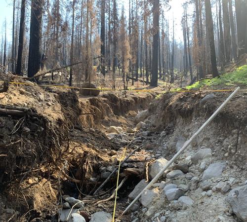 Scoured stream channel in the Dixie Fire burn area. Measuring the amount of material removed by runoff is just one aspect of post-fire response activity. Photo credit: Don Lindsay, CGS.
To improve understanding of post-fire hazards throughout California, the BWG program conducts post-fire monitoring. These monitoring efforts include quantifying rainfall and runoff response in watersheds experiencing moderate-to-high soil burn severity.
Work performed as part of this monitoring effort is often conducted in close collaboration with state, federal, and local agencies and academic institutions. The information obtained is used to test current post-fire runoff and debris flow thresholds and models, to assess potential impacts to downstream people, property, and infrastructure, and to inform the effectiveness of mitigation measures.
