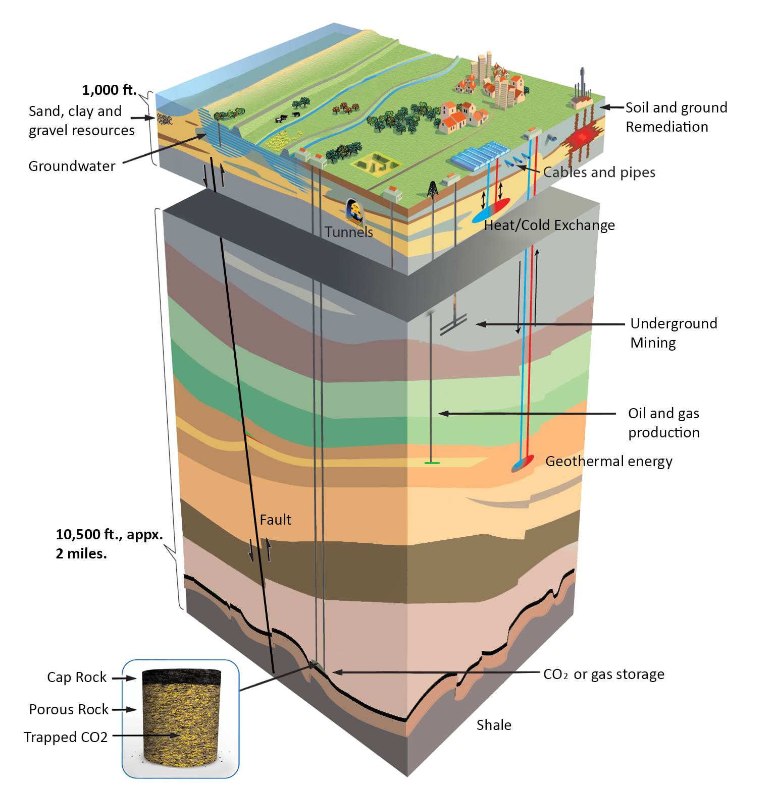
 Figure 1. Conceptual 3D geologic diagram showing CO2 injection and storage co-located among other uses and interests. Geologic carbon sequestration works by injecting CO2 deep below the earth's surface into a naturally-occurring formation of porous rock. Click the image to open a larger version in a new window. Source: Modified from TNO, Geological Survey of the Netherlands, and the Global CCS Institute.
The sustainable engineered removal of carbon dioxide (CO2) via geologic sequestration is largely dependent on underground geologic factors and risks. Geologic sequestration via the injection of CO2 into underground rock reservoirs is efficient at depths below 3,000 feet of the earth's surface, where CO2 is denser at this depth, and becomes what is termed a supercritical fluid under the earth's pressures that naturally exist (see figure 1). For reference, groundwater aquifers in California are typically a few hundred feet deep, and rarely deeper than 1,000 feet. Supercritical fluids behave as both a gas and liquid, taking up less space and dispersing through pore spaces in rock formations faster than either gases or ordinary liquids.
Underground oil and gas storage in geologic reservoirs has a long history in California and many other places globally. Oil and gas reservoirs are themselves long-term storage sites, where hydrocarbons are known to be sealed in geologic formations for millions of years without leakage.
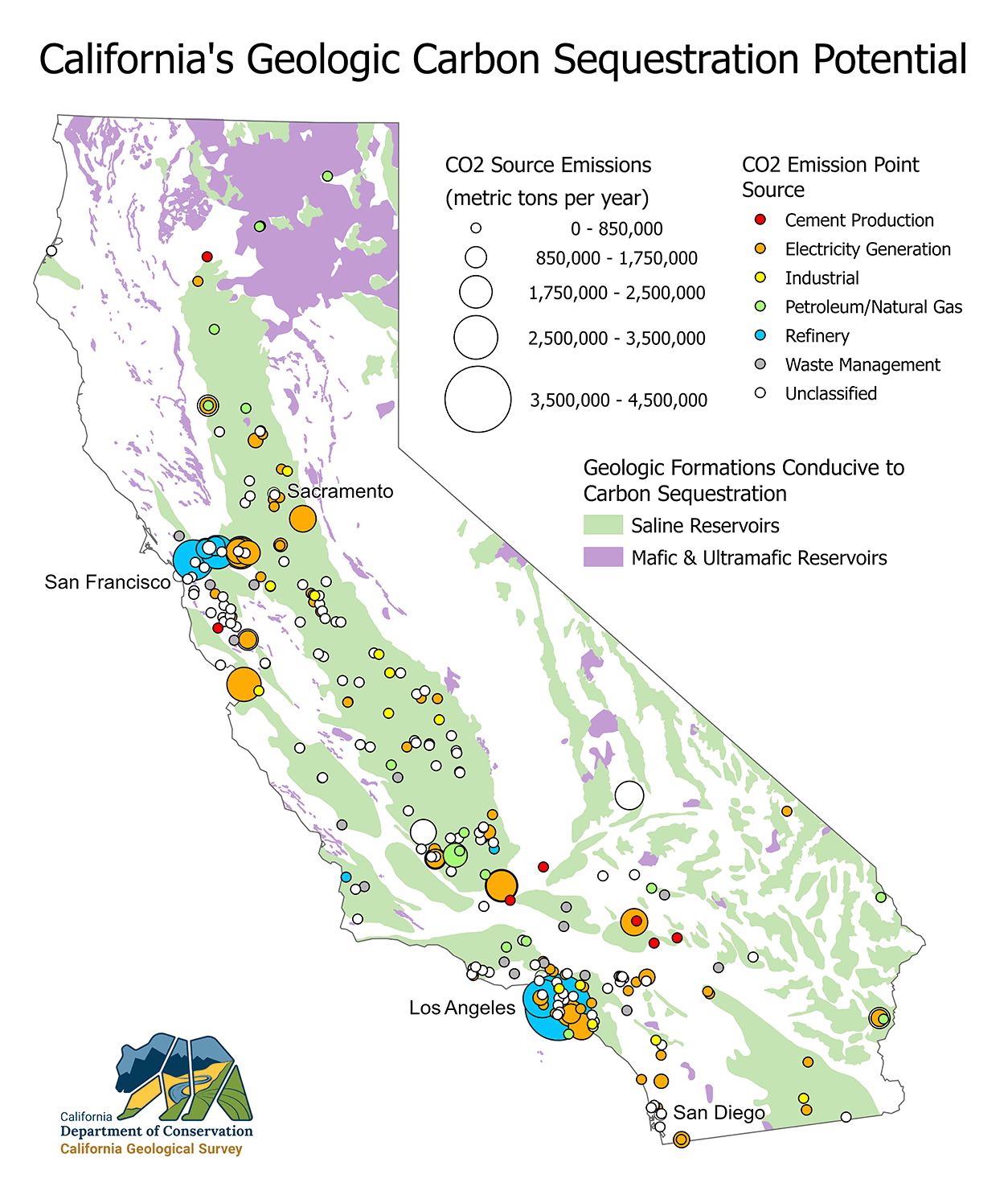 Figure 2. California has several types of geologic formations conducive to carbon sequestration. Click the image to open a larger version in a new window.
What is both different and urgent at present, is that to reach its greenhouse gas reduction target and carbon neutrality goals, California is transitioning away from technologies emitting carbon dioxide, particularly in the transportation, industrial, and electricity sectors. Removal and permanent sequestration of CO2 that results from fossil fuel and industrial sources is also a critical component of California's plan to reach carbon neutrality.
To prepare for this rapid transformation, the California Legislature passed Senate Bill 905 (SB 905), signed by the Governor in September 2022. This law mandates the establishment of a Geologic Carbon Sequestration Group (GCSG) in the California Geological Survey (CGS) to provide technical support to the California Air Resources Board (CARB) and to assess the suitability of the state's geologic carbon sequestration and removal potential. Unlike hydrocarbons that are concentrated in only a few general regions of the state, there is opportunity to utilize geologic reservoirs for CO2 sequestration all over the state. California has several types of geologic formations conducive to geologic sequestration. See the map of California's Geologic Carbon Sequestration Potential (figure 2) that includes the following types of geologic storage reservoirs:
- Deep saline aquifers, underground rock formations whose pore space is saturated with saltwater.
- Depleted oil and natural gas reservoirs, a subset of saline aquifer space containing underground rock reservoirs with pore space that at one time held significant amounts of oil or natural gas, but are now mostly filled with saltwater.
- Mafic and ultramafic rocks such as basalt, a volcanic rock with a chemical makeup that converts the CO2 to a solid mineral form, turning CO2 into rock.
Tasks of the Geologic Carbon Sequestration Group (GCSG)
The CGS GCSG is mandated to provide independent expertise and regulatory guidance to CARB, including, but not limited to the assessment of:
- High quality, suitable locations for Class VI injection wells (Class VI is the US EPA designation for wells used to inject CO2 into deep rock formations for purposes of long-term sequestration).
- Appropriate subsurface monitoring to ensure geologic sequestration of injected carbon dioxide.
- Hazards that may require the suspension of carbon dioxide injections.
In addition, the GCSG shall report seismic activity or [subsurface] leakage of carbon dioxide from a carbon dioxide capture, removal, or sequestration project to CARB and may recommend changes in the operations of the project to CARB.
There is an urgent need now to assess the geologic opportunities and risks for clean energy CO2 sequestration and removal systems and to provide easily accessible maps, models, and data products, so that the geoscientific process and its results can fully inform the safe development and implementation of sequestration and removal projects, regulations, and policies. In advance of development, the CGS GCSG will begin the suitability analysis by mapping the general distribution and character of potential sequestration opportunities throughout the state, followed by identifying the relative risks to safe storage, such as leakage and seismic activity. The CGS will be providing technical support in many ways. These might include working with operators to develop and implement seismic and CO2 plume monitoring. Seismic monitoring is the detection of small earthquake energy releases from both natural and induced causes (usually not felt at the surface by people) by sensitive devices called seismometers. In addition, the GCSG can evaluate potential plume migration in advance of injection, through complex computer simulations used to predict movement and changes over time. During and after injection, plume development and migration will be monitored with seismic imaging data (see figure 3 below from the Sleipner project in Norway) in conjunction with the analysis of injection and monitoring well data.
U.S. and Global Examples
Geologic storage and sequestration of CO2 has been underway for several decades with projects in Norway, Algeria, a joint U.S.-Canadian effort at the Dakota Gasification facility in North Dakota, and the Weyburn field in Saskatchewan. Numerous pilot- and commercial-scale projects have provided significant data and experience with a variety of natural reservoirs. Many field projects in the U.S. and Canada are being developed in saline aquifers and depleted oil reservoirs through the U.S. Department of Energy's Regional Carbon Sequestration Partnerships, regional partnerships between private companies, universities, and governmental agencies. Thus far, no evidence suggests significant volumes of CO2 have migrated out of the confining reservoirs, indicating that long-term storage is feasible.
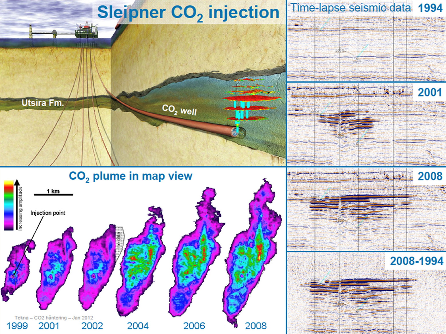 Figure 3. The Sleipner CO2 injection project in Norway has been in operation since 1996. The time-lapse seismic data on the right shows how the CO2 plume has been monitored over time. Source: Equinor ASA.
As part of the previous U.S. Department of Energy West Coast Regional Carbon Sequestration Partnership, the CGS conducted a preliminary assessment of geologic carbon sequestration potential in California in 2005. This involved identifying and characterizing porous (void spaces in the rock that constitute reservoir volume) and permeable (a measure of how well fluids flow through rock) geologic reservoir formations, and defining areas within the state's sedimentary basins that may be geologically suitable for carbon sequestration in both saline aquifers or producing or abandoned oil and gas reservoirs. Information was compiled in digital and geographic information system (GIS) formats to facilitate spatial analysis and use by other partnership participants. The CGS identified and cataloged sedimentary basins within California. Inventoried basins included all large or hydrocarbon-producing basins, as well as other smaller basins identified from geologic mapping work in California. The resulting 104 basins (shown in green in figure 2 above) were screened to determine preliminary suitability for carbon sequestration. Criteria included the presence of significant porous and permeable reservoirs, seals, and sediment thickness sufficient for supercritical state carbon dioxide injection. Of the 104 basins, 27 met the criteria for further assessment. The assessment did not include a more robust 3D mapping of the reservoirs and overlying sealing caprock formations needed to address permanence guidance of the U.S. Environmental Protection Agency.
The CGS GCSG is continuing this assessment work at a level commensurate with the state's needs, including new geologic targets and risks previously not considered (i.e., ultramafic and mafic rock reservoirs, and subsurface seismic sources, respectively).
The following links are provided for additional information regarding the development and regulation of CCS projects in California.
